
Wyton topographic map
Click on the map to display elevation.
About this map
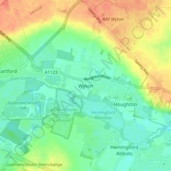
Name: Wyton topographic map, elevation, terrain.
Average elevation: 19 m
Minimum elevation: 2 m
Maximum elevation: 44 m
Other topographic maps
Click on a map to view its topography, its elevation and its terrain.
Brampton
United Kingdom > England > Cambridgeshire > Huntingdonshire > Brampton
Average elevation: 22 m
Hinchingbrooke Country Park
United Kingdom > England > Cambridgeshire > Huntingdonshire > Huntingdon > Brampton
Average elevation: 16 m
Kimbolton
United Kingdom > England > Cambridgeshire > Huntingdonshire > Kimbolton
Average elevation: 54 m
Bluntisham
United Kingdom > England > Cambridgeshire > Huntingdonshire > Bluntisham
Average elevation: 12 m
Kings Ripton
United Kingdom > England > Cambridgeshire > Huntingdonshire > Kings Ripton
Average elevation: 34 m
Catworth
United Kingdom > England > Cambridgeshire > Huntingdonshire > Catworth
Average elevation: 54 m
Old Weston
United Kingdom > England > Cambridgeshire > Huntingdonshire > Old Weston
Average elevation: 65 m
Great Staughton
United Kingdom > England > Cambridgeshire > Huntingdonshire > Great Staughton
Average elevation: 43 m
Holywell-cum-Needingworth
United Kingdom > England > Cambridgeshire > Huntingdonshire
Average elevation: 10 m
Hail Weston
United Kingdom > England > Cambridgeshire > Huntingdonshire > Hail Weston
Average elevation: 31 m
Hemingford Grey
United Kingdom > England > Cambridgeshire > Huntingdonshire > Hemingford Grey
Average elevation: 11 m
Abbots Ripton
United Kingdom > England > Cambridgeshire > Huntingdonshire > Abbots Ripton
Average elevation: 38 m
Broughton
United Kingdom > England > Cambridgeshire > Huntingdonshire > Broughton
Average elevation: 31 m
Woodhurst
United Kingdom > England > Cambridgeshire > Huntingdonshire > Woodhurst
Average elevation: 31 m
Hartford Marina
United Kingdom > England > Cambridgeshire > Huntingdonshire > Wyton
Average elevation: 14 m
Mill Pool
United Kingdom > England > Cambridgeshire > Huntingdonshire > Huntingdon
Average elevation: 14 m
Offord Cluny and Offord D'Arcy
United Kingdom > England > Cambridgeshire > Huntingdonshire > Offord Darcy
Average elevation: 31 m
Bluntisham
United Kingdom > England > Cambridgeshire > Huntingdonshire > Bluntisham
Average elevation: 12 m
Kimbolton
United Kingdom > England > Cambridgeshire > Huntingdonshire > Kimbolton
Average elevation: 54 m