
Clearwater topographic map
Interactive map
Click on the map to display elevation.
About this map
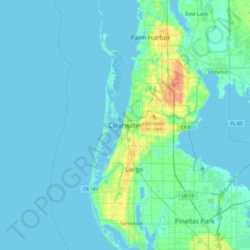
Name: Clearwater topographic map, elevation, terrain.
Location: Clearwater, Pinellas County, Florida, 33756, United States (27.80585 -82.96010 28.12585 -82.64010)
Average elevation: 4 m
Minimum elevation: -2 m
Maximum elevation: 35 m
Other topographic maps
Click on a map to view its topography, its elevation and its terrain.
Clearwater Harbor
United States > Florida > Pinellas County > Clearwater
Clearwater Harbor, Clearwater, Pinellas County, Florida, 33767, United States
Average elevation: 3 m
Bayview
United States > Florida > Pinellas County > Clearwater
Bayview, Clearwater, Pinellas County, Florida, 34619, United States
Average elevation: 6 m
Coachman
United States > Florida > Pinellas County > Clearwater > Coachman
Coachman, Clearwater, Pinellas County, Florida, 33765, United States
Average elevation: 19 m