Geolocate

Middle Fork of Wildcat Creek topographic map

Interactive map

Click on the map to display elevation.

About this map

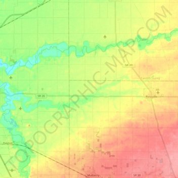
Name: Middle Fork of Wildcat Creek topographic map, elevation, terrain.

Location: Middle Fork of Wildcat Creek, Clinton County, Indiana, 46065, USA (40.40216 -86.77086 40.44585 -86.55551)

Average elevation: 215 m

Minimum elevation: 174 m

Maximum elevation: 256 m

Other topographic maps

Click on a map to view its topography, its elevation and its terrain.

Wayne County

USA > Indiana

Wayne County, Indiana, USA

Average elevation: 322 m

Maple Lane

USA > Indiana > Maple Lane

Maple Lane, Saint Joseph County, Indiana, 46617:46635, USA

Average elevation: 229 m

Griffith

USA > Indiana > Griffith

Griffith, Lake County, Indiana, 46319, USA

Average elevation: 190 m

Mount Etna

USA > Indiana > Mount Etna

Mount Etna, Huntington County, Indiana, USA

Average elevation: 245 m

Crocker

USA > Indiana > Crocker

Crocker, Porter County, Indiana, USA

Average elevation: 194 m

Chandler

USA > Indiana > Chandler

Chandler, Pike County, Indiana, USA

Average elevation: 151 m

Corunna

USA > Indiana > Corunna

Corunna, DeKalb County, Indiana, USA

Average elevation: 295 m

Saturn

USA > Indiana > Saturn

Saturn, Whitley County, Indiana, USA

Average elevation: 257 m