
Thank you for supporting this site ❤️
Make a donation
Make a donation
Burbank topographic map
Click on the map to display elevation.
Thank you for supporting this site ❤️
Make a donation
Make a donation
Burbank
Elevations in the city range from 500 feet (150 m) in the lower valley areas to about 800 feet (240 m) near the Verdugo Mountains. Most of Burbank features a water table more than 100 feet (30 m) deep, more than the measures found in the 1940s when the water table was within 50 feet (15 m) of the ground surface in some areas of Burbank.
Thank you for supporting this site ❤️
Make a donation
Make a donation
About this map
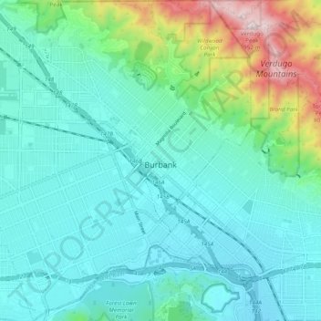
Name: Burbank topographic map, elevation, terrain.
Location: Burbank, Los Angeles County, California, United States (34.14266 -118.37017 34.22165 -118.28003)
Average elevation: 251 m
Minimum elevation: 128 m
Maximum elevation: 947 m
Thank you for supporting this site ❤️
Make a donation
Make a donation