
Thank you for supporting this site ❤️
Make a donation
Make a donation
Pals topographic map
Click on the map to display elevation.
Thank you for supporting this site ❤️
Make a donation
Make a donation
About this map
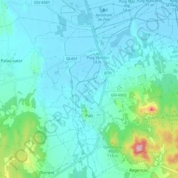
Name: Pals topographic map, elevation, terrain.
Location: Pals, Baix Empordà, Gerona, Catalonië, 17256, Spanje (41.94975 3.13471 42.01050 3.20749)
Average elevation: 33 m
Minimum elevation: -3 m
Maximum elevation: 212 m
Thank you for supporting this site ❤️
Make a donation
Make a donation
Other topographic maps
Click on a map to view its topography, its elevation and its terrain.
Cruïlles
Spanje > Catalonië > Baix Empordà > Cruïlles, Monells i Sant Sadurní de l'Heura
Average elevation: 66 m
Thank you for supporting this site ❤️
Make a donation
Make a donation
Platja d'Aro
Spanje > Catalonië > Baix Empordà > Castell d'Aro, Platja d'Aro i s'Agaró
Average elevation: 47 m
Thank you for supporting this site ❤️
Make a donation
Make a donation