
Camogli topographic map
Interactive map
Click on the map to display elevation.
About this map
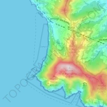
Name: Camogli topographic map, elevation, terrain.
Location: Camogli, Genua, Ligurien, Italien (44.30866 9.14503 44.35763 9.19409)
Average elevation: 123 m
Minimum elevation: -1 m
Maximum elevation: 594 m
Other topographic maps
Click on a map to view its topography, its elevation and its terrain.
Monte Cornua
Monte Cornua, Avegno, Genua, Ligurien, 16024, Italien
Average elevation: 422 m
Forte Geremia
Italien > Ligurien > Genua > Mele
Forte Geremia, Polveriera, Mele, Genua, Ligurien, 16013, Italien
Average elevation: 578 m