
Florianópolis topographic map
Interactive map
Click on the map to display elevation.
About this map
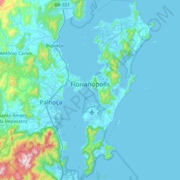
Name: Florianópolis topographic map, elevation, terrain.
Average elevation: 92 m
Minimum elevation: -3 m
Maximum elevation: 1,275 m
Florianópolis lies within the Atlantic Forest which has an extremely diverse and unique mix of vegetation and forest types. The main ecoregion is the coastal Atlantic forest, the narrow strip of about 50–100 kilometers (31–62 miles) along the coast which covers about 20 percent of the region. This forest extends as far as 500–600 kilometers (310–370 miles) inland and its range is as high as 2,000 meters above sea level. Altitude determines at least three vegetation types in the Atlantic Forest: the lowland forest of the coastal plain, montane forests, and the high-altitude grassland or "campo rupestre."
Other topographic maps
Click on a map to view its topography, its elevation and its terrain.
Alfredo Wagner
Alfredo Wagner, Região Geográfica Imediata de Florianópolis, Região Geográfica Intermediária de Florianópolis, Santa Catarina, South Region, 88450-000, Brazil
Average elevation: 858 m
Caminho
Brazil > Santa Catarina > Dona Emma > Caminho
Caminho, Dona Emma, Região Geográfica Imediata de Ibirama-Presidente Getúlio, Santa Catarina, South Region, Brazil
Average elevation: 460 m
Blumenau
Brazil > Santa Catarina > Blumenau
Blumenau, Região Geográfica Imediata de Blumenau, Santa Catarina, South Region, Brazil
Average elevation: 220 m
Residência Fuck
Brazil > Santa Catarina > Monte Castelo
Residência Fuck, Monte Castelo, Região Geográfica Imediata de Mafra, Região Geográfica Intermediária de Joinville, Santa Catarina, South Region, 89380-000, Brazil
Average elevation: 845 m
Serra do Rio do Rastro
Brazil > Santa Catarina > Bom Jardim da Serra
Serra do Rio do Rastro, Rodovia Governador Irineu Bornhausen, Bom Jardim da Serra, Microrregião de Campos de Lages, Mesorregião Serrana, Santa Catarina, South Region, 88640-000, Brazil
Average elevation: 1,076 m