
Point View Reserve topographic map
Interactive map
Click on the map to display elevation.
About this map
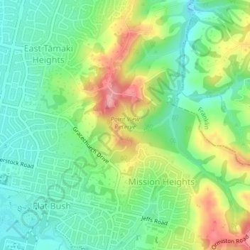
Name: Point View Reserve topographic map, elevation, terrain.
Average elevation: 59 m
Minimum elevation: 14 m
Maximum elevation: 136 m
Other topographic maps
Click on a map to view its topography, its elevation and its terrain.
Cockle Bay
New Zealand > Auckland > Howick
Cockle Bay, Howick, Auckland, 2014, New Zealand
Average elevation: 17 m
Buckland Beach
New Zealand > Auckland > Howick
Buckland Beach, Bucklands Beach, Howick, Auckland, New Zealand
Average elevation: 11 m
Eastern Beach
New Zealand > Auckland > Howick
Eastern Beach, Howick, Auckland, New Zealand
Average elevation: 13 m
Murphys Bush
New Zealand > Auckland > Howick
Murphys Bush, Donegal Park, Howick, Howick Ward, Auckland, New Zealand
Average elevation: 59 m