
Santiago de los Caballeros topographic map
Interactive map
Click on the map to display elevation.
About this map
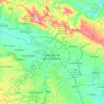
Name: Santiago de los Caballeros topographic map, elevation, terrain.
Location: Santiago de los Caballeros, Santiago, Dominican Republic (19.28406 -70.90852 19.65092 -70.61598)
Average elevation: 341 m
Minimum elevation: 46 m
Maximum elevation: 1,223 m
Santiago de los Caballeros (Spanish pronunciation: [sanˈtjaɣo ðe los kaβaˈʝeɾos]; English: Saint James of the Knights), often shortened to Santiago, is the second-largest city in the Dominican Republic and the fourth-largest city in the Caribbean by population. It is the capital of Santiago Province and the largest major metropolis in the Cibao region of the country. Santiago is the largest Caribbean city that isn’t a capital city, and it is also the largest non-coastal metropolis in the Caribbean islands. The city has a total population of 1,173,015 inhabitants. Santiago is located approximately 155 km (96 mi) northwest of the capital Santo Domingo with an average altitude of 178 meters (584 ft).