
Make a donation
Castrop-Rauxel topographic map
Click on the map to display elevation.
Make a donation
Castrop-Rauxel
The city covers an area of 51.67 km2 (19.95 sq mi). The Halde Schwerin (slag heap in the Schwerin district) is marked as the point of highest elevation at 147 m (482.3 ft) above sea level. The lowest point is located on Pöppinghauser Straße (Poppinghausen Street), besides house number 264, with an elevation of 50.2 m (164.7 ft) above sea level.
Make a donation
About this map
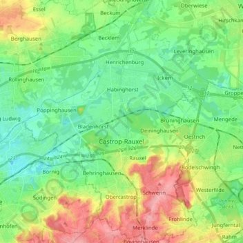
Name: Castrop-Rauxel topographic map, elevation, terrain.
Average elevation: 75 m
Minimum elevation: 42 m
Maximum elevation: 137 m
Make a donation
Other topographic maps
Click on a map to view its topography, its elevation and its terrain.
Sythen
Germany > North Rhine-Westphalia > Kreis Recklinghausen > Haltern am See
Average elevation: 54 m
Holtwick
Germany > North Rhine-Westphalia > Kreis Recklinghausen > Haltern am See
Average elevation: 89 m