
Ostrów Wielkopolski County topographic map
Interactive map
Click on the map to display elevation.
About this map
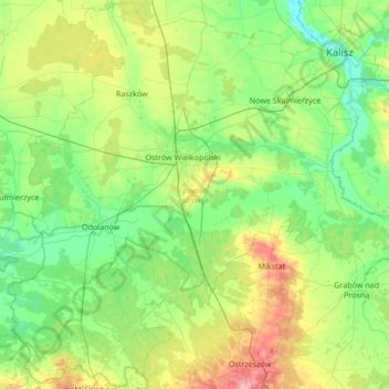
Name: Ostrów Wielkopolski County topographic map, elevation, terrain.
Location: Ostrów Wielkopolski County, Greater Poland Voivodeship, Poland (51.39949 17.51216 51.81646 18.18842)
Average elevation: 141 m
Minimum elevation: 97 m
Maximum elevation: 269 m
Other topographic maps
Click on a map to view its topography, its elevation and its terrain.
Latowice
Poland > Greater Poland Voivodeship > Ostrów Wielkopolski County
Latowice, gmina Sieroszewice, Ostrów Wielkopolski County, Greater Poland Voivodeship, 63-405, Poland
Average elevation: 137 m
Poznań
Poland > Greater Poland Voivodeship > Poznań County
Poznań, Poznań County, Greater Poland Voivodeship, Poland
Average elevation: 85 m
Radzewo
Poland > Greater Poland Voivodeship > Poznań County
Radzewo, gmina Kórnik, Poznań County, Greater Poland Voivodeship, Poland
Average elevation: 76 m
Środa Wielkopolska County
Poland > Greater Poland Voivodeship
Środa Wielkopolska County, Greater Poland Voivodeship, Poland
Average elevation: 85 m
Pępowo
Poland > Greater Poland Voivodeship > Gostyń County
Pępowo, gmina Pępowo, Gostyń County, Greater Poland Voivodeship, 63-830, Poland
Average elevation: 121 m
Bryś-Folwark
Poland > Greater Poland Voivodeship > Piła County > Skrzatusz
Bryś-Folwark, Skrzatusz, gmina Szydłowo, Piła County, Greater Poland Voivodeship, Poland
Average elevation: 149 m
Morasko
Poland > Greater Poland Voivodeship > Poznań
Morasko, Morasko-Radojewo, Poznan, Greater Poland Voivodeship, Poland
Average elevation: 108 m
Leszno
Poland > Greater Poland Voivodeship
Leszno, Greater Poland Voivodeship, Poland
Average elevation: 97 m
Mosina
Poland > Greater Poland Voivodeship > Poznań County
Mosina, gmina Mosina, Poznań County, Greater Poland Voivodeship, 62-050, Poland
Average elevation: 71 m
Koło
Poland > Greater Poland Voivodeship > Koło County
Koło, Koło County, Greater Poland Voivodeship, Poland
Average elevation: 100 m
Młodojewo-Parcele
Poland > Greater Poland Voivodeship > Słupca County
Młodojewo-Parcele, gmina Słupca, Słupca County, Greater Poland Voivodeship, 62-400, Poland
Average elevation: 97 m
Szczepankowo-Spławie-Krzesinki
Poland > Greater Poland Voivodeship > Poznań
Szczepankowo-Spławie-Krzesinki, Poznan, Greater Poland Voivodeship, Poland
Average elevation: 82 m
Czarnków
Poland > Greater Poland Voivodeship > Czarnków-Trzcianka County
Czarnków, Czarnków-Trzcianka County, Greater Poland Voivodeship, 64-700, Poland
Average elevation: 74 m
Poznan
Poland > Greater Poland Voivodeship
Poznan, Greater Poland Voivodeship, Poland
Average elevation: 85 m
Bielsko
Poland > Greater Poland Voivodeship > Słupca County
Bielsko, gmina Orchowo, Słupca County, Greater Poland Voivodeship, 62-436, Poland
Average elevation: 107 m
Jastrowie
Poland > Greater Poland Voivodeship > Złotów County
Jastrowie, gmina Jastrowie, Złotów County, Greater Poland Voivodeship, Poland
Average elevation: 116 m
Piła County
Poland > Greater Poland Voivodeship
Piła County, Greater Poland Voivodeship, Poland
Average elevation: 99 m
Unisław
Poland > Greater Poland Voivodeship > Krotoszyn County
Unisław, gmina Krotoszyn, Krotoszyn County, Greater Poland Voivodeship, 63-703, Poland
Average elevation: 128 m
Marcinek
Poland > Greater Poland Voivodeship > Chodzież County
Marcinek, gmina Margonin, Chodzież County, Greater Poland Voivodeship, 64-830, Poland
Average elevation: 90 m
Nowy Tomyśl
Poland > Greater Poland Voivodeship > Nowy Tomyśl County
Nowy Tomyśl, gmina Nowy Tomyśl, Nowy Tomyśl County, Greater Poland Voivodeship, 64-300, Poland
Average elevation: 74 m
Stęszew
Poland > Greater Poland Voivodeship > Poznań County
Stęszew, gmina Stęszew, Poznań County, Greater Poland Voivodeship, Poland
Average elevation: 76 m
Rawicz
Poland > Greater Poland Voivodeship > Rawicz County
Rawicz, gmina Rawicz, Rawicz County, Greater Poland Voivodeship, 63-900, Poland
Average elevation: 96 m
Nadarzyce
Poland > Greater Poland Voivodeship > Września County
Nadarzyce, gmina Września, Września County, Greater Poland Voivodeship, Poland
Average elevation: 102 m
Roszkowo
Poland > Greater Poland Voivodeship > Wągrowiec County
Roszkowo, gmina Skoki, Wągrowiec County, Greater Poland Voivodeship, 62-085, Poland
Average elevation: 90 m
Meszna
Poland > Greater Poland Voivodeship > Słupca County
Meszna, gmina Słupca, Słupca County, Greater Poland Voivodeship, 62-400, Poland
Average elevation: 99 m
Kobyla Góra
Poland > Greater Poland Voivodeship > Ostrzeszów County
Kobyla Góra, gmina Kobyla Góra, Ostrzeszów County, Greater Poland Voivodeship, 63-507, Poland
Average elevation: 220 m
Pilich
Poland > Greater Poland Voivodeship > Konin County
Pilich, gmina Skulsk, Konin County, Greater Poland Voivodeship, 62-560, Poland
Average elevation: 97 m
Ostrzeszów
Poland > Greater Poland Voivodeship > Ostrzeszów County
Ostrzeszów, gmina Ostrzeszów, Ostrzeszów County, Greater Poland Voivodeship, 63-500, Poland
Average elevation: 213 m
Będlewo
Poland > Greater Poland Voivodeship > Poznań County
Będlewo, gmina Stęszew, Poznań County, Greater Poland Voivodeship, Poland
Average elevation: 73 m
Komorniki
Poland > Greater Poland Voivodeship > Poznań County
Komorniki, gmina Komorniki, Poznań County, Greater Poland Voivodeship, 62-052, Poland
Average elevation: 84 m
Konin
Poland > Greater Poland Voivodeship
Konin, Greater Poland Voivodeship, Poland
Average elevation: 93 m
Kalisz
Poland > Greater Poland Voivodeship > Kalisz
Kalisz, Greater Poland Voivodeship, 62-800, Poland
Average elevation: 125 m
Stępocin
Poland > Greater Poland Voivodeship > Września County
Stępocin, gmina Nekla, Września County, Greater Poland Voivodeship, Poland
Average elevation: 109 m
Wiry
Poland > Greater Poland Voivodeship > Poznań County
Wiry, gmina Komorniki, Poznań County, Greater Poland Voivodeship, 62-051, Poland
Average elevation: 81 m
Gniezno
Poland > Greater Poland Voivodeship > Gniezno County > Gniezno
Gniezno, Gniezno County, Greater Poland Voivodeship, Poland
Average elevation: 119 m
Poznań
Poland > Greater Poland Voivodeship > Poznań > Poznań
Poznań, Greater Poland Voivodeship, 60-001, Poland
Average elevation: 86 m
Mszczyczyn
Poland > Greater Poland Voivodeship > Śrem County > Mszczyczyn
Mszczyczyn, gmina Dolsk, Śrem County, Greater Poland Voivodeship, 63-140, Poland
Average elevation: 98 m
Szamotuły County
Poland > Greater Poland Voivodeship
Szamotuły County, Greater Poland Voivodeship, Poland
Average elevation: 81 m
Poznań
Poland > Greater Poland Voivodeship > Poznań County
Poznań, Poznań County, Greater Poland Voivodeship, Poland
Average elevation: 85 m
Dąbie
Poland > Greater Poland Voivodeship > Koło County > Dąbie > Dąbie
Dąbie, gmina Dąbie, Koło County, Greater Poland Voivodeship, 62-660, Poland
Average elevation: 103 m
Trzebaw
Poland > Greater Poland Voivodeship > Poznań County
Trzebaw, gmina Stęszew, Poznań County, Greater Poland Voivodeship, Poland
Average elevation: 79 m
Buk
Poland > Greater Poland Voivodeship > Poznań County > Buk
Buk, gmina Buk, Poznań County, Greater Poland Voivodeship, Poland
Average elevation: 86 m
Kalisz County
Poland > Greater Poland Voivodeship
Kalisz County, Greater Poland Voivodeship, Poland
Average elevation: 132 m
Jarocin County
Poland > Greater Poland Voivodeship
Jarocin County, Greater Poland Voivodeship, Poland
Average elevation: 104 m
Karszew
Poland > Greater Poland Voivodeship > Koło County > Karszew
Karszew, gmina Dąbie, Koło County, Greater Poland Voivodeship, 62-660, Poland
Average elevation: 106 m
Swarzędz
Poland > Greater Poland Voivodeship > Poznań County > Swarzędz
Swarzędz, gmina Swarzędz, Poznań County, Greater Poland Voivodeship, 62-020, Poland
Average elevation: 87 m
Róża
Poland > Greater Poland Voivodeship > Słupca County
Róża, gmina Słupca, Słupca County, Greater Poland Voivodeship, 62-400, Poland
Average elevation: 94 m
Skórzewo
Poland > Greater Poland Voivodeship > Skórzewo
Skórzewo, gmina Dopiewo, Poznań County, Greater Poland Voivodeship, 60-185, Poland
Average elevation: 85 m
Konin County
Poland > Greater Poland Voivodeship
Konin County, Greater Poland Voivodeship, Poland
Average elevation: 104 m
Koło County
Poland > Greater Poland Voivodeship
Koło County, Greater Poland Voivodeship, Poland
Average elevation: 113 m