
Thank you for supporting this site ❤️
Make a donation
Make a donation
Jefferson topographic map
Click on the map to display elevation.
Thank you for supporting this site ❤️
Make a donation
Make a donation
About this map
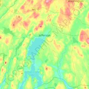
Name: Jefferson topographic map, elevation, terrain.
Location: Jefferson, Lincoln County, Maine, 04348, United States (44.10102 -69.59175 44.27546 -69.40363)
Average elevation: 60 m
Minimum elevation: 2 m
Maximum elevation: 160 m
Thank you for supporting this site ❤️
Make a donation
Make a donation
Other topographic maps
Click on a map to view its topography, its elevation and its terrain.