
Andreas Berg topographic map
Interactive map
Click on the map to display elevation.
About this map
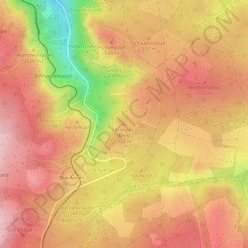
Name: Andreas Berg topographic map, elevation, terrain.
Average elevation: 517 m
Minimum elevation: 363 m
Maximum elevation: 600 m
Other topographic maps
Click on a map to view its topography, its elevation and its terrain.
Schierke
Deutschland > Sachsen-Anhalt > Landkreis Harz > Wernigerode
Schierke, Wernigerode, Landkreis Harz, Sachsen-Anhalt, 38879, Deutschland
Average elevation: 707 m
Brocken
Deutschland > Sachsen-Anhalt > Landkreis Harz > Wernigerode
Brocken, Wernigerode, Landkreis Harz, Sachsen-Anhalt, Deutschland
Average elevation: 963 m
Astberg
Deutschland > Sachsen-Anhalt > Landkreis Harz > Wernigerode
Astberg, Wernigerode, Landkreis Harz, Sachsen-Anhalt, Deutschland
Average elevation: 443 m
Kanzelklippe
Deutschland > Sachsen-Anhalt > Landkreis Harz > Wernigerode > Schierke
Kanzelklippe, Schierke, Wernigerode, Landkreis Harz, Sachsen-Anhalt, 38879, Deutschland
Average elevation: 834 m
Benzingerode
Deutschland > Sachsen-Anhalt > Landkreis Harz > Wernigerode
Benzingerode, Wernigerode, Landkreis Harz, Sachsen-Anhalt, Deutschland
Average elevation: 275 m