
Thank you for supporting this site ❤️
Make a donation
Make a donation
Zoo Lake topographic map
Click on the map to display elevation.
Thank you for supporting this site ❤️
Make a donation
Make a donation
About this map
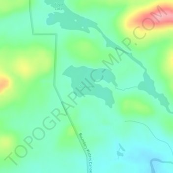
Name: Zoo Lake topographic map, elevation, terrain.
Location: Zoo Lake, West Cook, Cook County, Minnesota, United States (47.88987 -90.59005 47.89661 -90.57713)
Average elevation: 573 m
Minimum elevation: 538 m
Maximum elevation: 661 m
Thank you for supporting this site ❤️
Make a donation
Make a donation