
Bald Peak topographic map
Interactive map
Click on the map to display elevation.
About this map
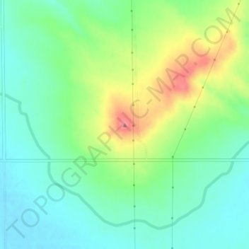
Name: Bald Peak topographic map, elevation, terrain.
Location: Bald Peak, Scotts Bluff County, Nebraska, United States (41.87520 -103.91055 41.87530 -103.91045)
Average elevation: 1,293 m
Minimum elevation: 1,264 m
Maximum elevation: 1,349 m
Other topographic maps
Click on a map to view its topography, its elevation and its terrain.
Terrytown
United States > Nebraska > Scotts Bluff County
Terrytown, Scotts Bluff County, Nebraska, United States
Average elevation: 1,186 m
Mitchell
United States > Nebraska > Scotts Bluff County
Mitchell, Scotts Bluff County, Nebraska, United States
Average elevation: 1,209 m
Scottsbluff
United States > Nebraska > Scotts Bluff County
Scottsbluff, Scotts Bluff County, Nebraska, 69361, United States
Average elevation: 1,190 m
Scottsbluff
United States > Nebraska > Scotts Bluff County > Scottsbluff
Scottsbluff, Scotts Bluff County, Nebraska, 69361, United States
Average elevation: 1,259 m
Melbeta
United States > Nebraska > Scotts Bluff County > Melbeta
Melbeta, Scotts Bluff County, Nebraska, United States
Average elevation: 1,166 m
Gering
United States > Nebraska > Scotts Bluff County > Gering
Gering, Scotts Bluff County, Nebraska, United States
Average elevation: 1,195 m