
El Jaiara topographic map
Interactive map
Click on the map to display elevation.
About this map
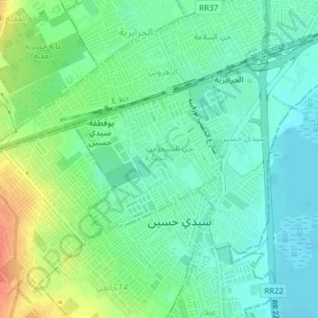
Name: El Jaiara topographic map, elevation, terrain.
Location: El Jaiara, Sidi Hassine, Tunis, Tunisie (36.76983 10.09900 36.78223 10.11477)
Average elevation: 19 m
Minimum elevation: 3 m
Maximum elevation: 52 m
Other topographic maps
Click on a map to view its topography, its elevation and its terrain.
Sidi Bou Saïd
Tunisie > Tunis > Sidi Bou Saïd
Sidi Bou Saïd, Sidi Bou Said, Carthage, Tunis, 2026, Tunisie
Average elevation: 13 m
Sebkha Séjoumi
Sebkha Séjoumi, RR 39 طج, Tunis, 25 Juillet, Fouchana, Tunis, 1145, Tunisie
Average elevation: 18 m
golfe de Tunis
golfe de Tunis, Carthage, Carthage Plage, Carthage, Tunis, Tunisie
Average elevation: 30 m