
Mont Beuvray topographic map
Interactive map
Click on the map to display elevation.
About this map
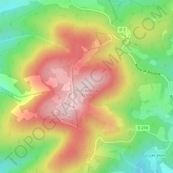
Name: Mont Beuvray topographic map, elevation, terrain.
Average elevation: 632 m
Minimum elevation: 446 m
Maximum elevation: 821 m
Other topographic maps
Click on a map to view its topography, its elevation and its terrain.
Saint-Léger-sous-Beuvray
Frankrijk > Bourgondië-Franche-Comté > Saône-et-Loire > Saint-Léger-sous-Beuvray
Saint-Léger-sous-Beuvray, Autun, Saône-et-Loire, Bourgondië-Franche-Comté, Metropolitaans Frankrijk, 71990, Frankrijk
Average elevation: 416 m