
Thank you for supporting this site ❤️
Make a donation
Make a donation
Rice Lake topographic map
Click on the map to display elevation.
Thank you for supporting this site ❤️
Make a donation
Make a donation
About this map
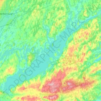
Name: Rice Lake topographic map, elevation, terrain.
Average elevation: 225 m
Minimum elevation: 177 m
Maximum elevation: 355 m
Thank you for supporting this site ❤️
Make a donation
Make a donation
Other topographic maps
Click on a map to view its topography, its elevation and its terrain.
Villiers
Canada > Ontario > Peterborough County > Otonabee–South Monaghan > Villiers
Average elevation: 225 m