
Herekino River topographic map
Interactive map
Click on the map to display elevation.
About this map
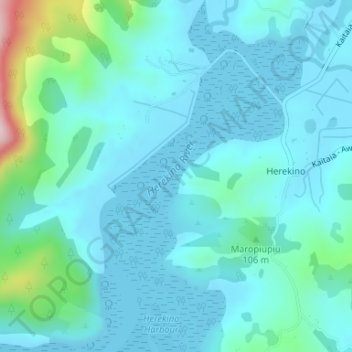
Name: Herekino River topographic map, elevation, terrain.
Average elevation: 46 m
Minimum elevation: 0 m
Maximum elevation: 310 m
Other topographic maps
Click on a map to view its topography, its elevation and its terrain.
Mangonui
New Zealand > Te Hiku Community > Mangonui
Mangonui, Te Hiku Community, Far North District, Northland, 0494, New Zealand
Average elevation: 25 m
Waihoe Channel
New Zealand > Te Hiku Community
Waihoe Channel, Te Hiku Community, Far North District, Northland, 0482, New Zealand
Average elevation: 8 m
Te Hiku Community
New Zealand > Te Hiku Community
Te Hiku Community, Far North District, Northland, New Zealand
Average elevation: 29 m
Tikorangi
New Zealand > Te Hiku Community
Tikorangi, Te Hiku Community, Far North District, Northland, New Zealand
Average elevation: 26 m
Manakau Stream
New Zealand > Te Hiku Community
Manakau Stream, Te Hiku Community, Far North District, Northland, New Zealand
Average elevation: 35 m