
Karagandy topographic map
Interactive map
Click on the map to display elevation.
Karagandy
Karaganda suffered the most severe electromagnetic pulse effects ever observed when its electrical power plant was set on fire by currents induced in a 1,000 km (620 mi) long shallow buried power cable by Soviet Test ‘184’ on 22 October 1962. The test was part of the Soviet Project K nuclear tests (ABM System A proof tests), and consisted of a 300-kiloton high-altitude nuclear explosion at an altitude of 290 km (180 mi) over Zhezkazgan.
About this map
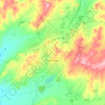
Name: Karagandy topographic map, elevation, terrain.
Location: Karagandy, Karaganda Region, Kazakhstan (49.68282 72.97522 49.99427 73.27738)
Average elevation: 542 m
Minimum elevation: 486 m
Maximum elevation: 645 m