
Thank you for supporting this site ❤️
Make a donation
Make a donation
Hiram topographic map
Click on the map to display elevation.
Thank you for supporting this site ❤️
Make a donation
Make a donation
About this map
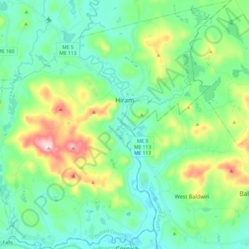
Name: Hiram topographic map, elevation, terrain.
Location: Hiram, Oxford County, Maine, 04041, United States (43.80451 -70.89438 43.92834 -70.72978)
Average elevation: 178 m
Minimum elevation: 78 m
Maximum elevation: 481 m
Thank you for supporting this site ❤️
Make a donation
Make a donation
Other topographic maps
Click on a map to view its topography, its elevation and its terrain.
Sturtevant Pond
United States > Maine > Oxford County > Magalloway Plantation
Average elevation: 406 m
Mad River Falls
United States > Maine > Oxford County > Batchelders Grant Township
Average elevation: 495 m
Thank you for supporting this site ❤️
Make a donation
Make a donation