
Make a donation
Metro Manila topographic map
Click on the map to display elevation.
Make a donation
Metro Manila
The Coastal Margin or Lowland is a flat and low plain that faces Manila Bay. Located here is Manila, Navotas, parts of Malabon, and the western part and reclaimed areas of Pasay and Parañaque, where the ground elevation ranges from zero meters on Manila Bay to five meters (16 ft) at the west side of the cities of Mandaluyong and Makati. The Coastal Lowland possesses resources for offshore fisheries and fishpond development, and various reclamation projects in the area are meant for mixed-use urban development.
Make a donation
About this map
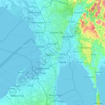
Name: Metro Manila topographic map, elevation, terrain.
Location: Metro Manila, Philippines (14.34780 120.79170 14.78534 121.13502)
Average elevation: 43 m
Minimum elevation: -4 m
Maximum elevation: 587 m
Make a donation
Other topographic maps
Click on a map to view its topography, its elevation and its terrain.
Antipolo
Its higher elevation than that of Metro Manila affords it a scenic view of the metropolis, especially at night. Its locally grown mangoes and cashews are popular among tourists, as well as suman – a local delicacy made out of glutinous rice. The Hinulugang Taktak National Park, which was once a popular…
Average elevation: 125 m
Make a donation
Make a donation
Make a donation
Make a donation
Make a donation
Muntinlupa
There are three plausible origins of the name of the city: First, is its association with the thin topsoil in the area; second, residents, purportedly replying to a question by Spaniards in the 16th century what the name of their place was, said “Monte sa Lupa”—apparently mistaking the question for what…
Average elevation: 41 m
Make a donation
Make a donation