
Thank you for supporting this site ❤️
Make a donation
Make a donation
Central Point topographic map
Click on the map to display elevation.
Thank you for supporting this site ❤️
Make a donation
Make a donation
Central Point
The city lies at an elevation of about 1,272 feet (388 m) along Oregon Highway 99 and Interstate 5 northwest of Medford. Jacksonville is to the south and Gold Hill to the northwest. The Central Oregon and Pacific Railroad passes through Central Point.
Thank you for supporting this site ❤️
Make a donation
Make a donation
About this map
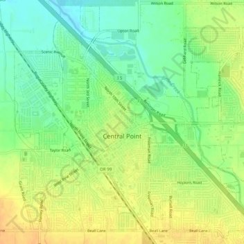
Name: Central Point topographic map, elevation, terrain.
Average elevation: 385 m
Minimum elevation: 368 m
Maximum elevation: 401 m
Thank you for supporting this site ❤️
Make a donation
Make a donation