
Imperia topographic map
Interactive map
Click on the map to display elevation.
About this map
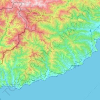
Name: Imperia topographic map, elevation, terrain.
Location: Imperia, Ligurie, Italie (43.77569 7.49516 44.14102 8.13540)
Average elevation: 604 m
Minimum elevation: 0 m
Maximum elevation: 2,636 m
Other topographic maps
Click on a map to view its topography, its elevation and its terrain.
Castello D'Albertis
Italie > Ligurie > Gênes > Gênes
Castello D'Albertis, Via di Montegalletto, Principe, Centro Est, Gênes, Ligurie, 16126, Italie
Average elevation: 105 m
Cinque Terre
Cinque Terre, Vernazza, La Spezia, Ligurie, 19010, Italie
Average elevation: 235 m
Rio Soernio
Rio Soernio, Bonassola, La Spezia, Ligurie, 19011, Italie
Average elevation: 144 m
Bussana Vecchia
Italie > Ligurie > Bussana Vecchia
Bussana Vecchia, Imperia, Ligurie, 18032, Italie
Average elevation: 114 m