
Thank you for supporting this site ❤️
Make a donation
Make a donation
Kilanas topographic map
Click on the map to display elevation.
Thank you for supporting this site ❤️
Make a donation
Make a donation
About this map
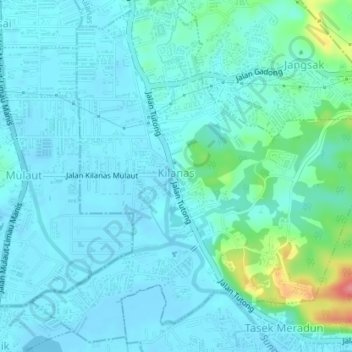
Name: Kilanas topographic map, elevation, terrain.
Location: Kilanas, Mukim Kilanas, Brunei-Muara District, BF2520, Brunei (4.85217 114.84833 4.88582 114.88397)
Average elevation: 14 m
Minimum elevation: -3 m
Maximum elevation: 90 m
Thank you for supporting this site ❤️
Make a donation
Make a donation
Other topographic maps
Click on a map to view its topography, its elevation and its terrain.