
Thank you for supporting this site ❤️
Make a donation
Make a donation
Bukoba topographic map
Click on the map to display elevation.
Thank you for supporting this site ❤️
Make a donation
Make a donation
Bukoba
Bukoba has an upland tropical monsoon climate (Köppen Amb, because every month has a normal mean temperature of between 18 °C and 22 °C) although it is milder than most climates with that classification due to its altitude. It can sometimes get cool especially in the evenings during the two rainy seasons, but never as cold as the winter season in Europe.
Thank you for supporting this site ❤️
Make a donation
Make a donation
About this map
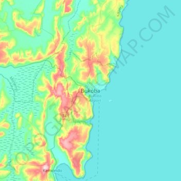
Name: Bukoba topographic map, elevation, terrain.
Location: Bukoba, Kagera, Lake Zone, Tanzania (-1.49115 31.65256 -1.17115 31.97256)
Average elevation: 1,177 m
Minimum elevation: 1,128 m
Maximum elevation: 1,405 m
Thank you for supporting this site ❤️
Make a donation
Make a donation
Other topographic maps
Click on a map to view its topography, its elevation and its terrain.
Thank you for supporting this site ❤️
Make a donation
Make a donation