
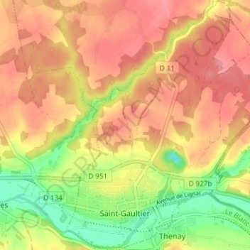
Saint-Gaultier topographic map
Interactive map
Click on the map to display elevation.
About this map
Name: Saint-Gaultier topographic map, elevation, terrain.
Average elevation: 134 m
Minimum elevation: 80 m
Maximum elevation: 170 m
Other topographic maps
Click on a map to view its topography, its elevation and its terrain.
Lys-Saint-Georges
France > Centre-Val de Loire > Indre
Lys-Saint-Georges, La Châtre, Indre, Centre-Val de Loire, France métropolitaine, 36230, France
Average elevation: 188 m
Châteauroux
France > Centre-Val de Loire > Indre > Châteauroux
Châteauroux, Indre, Centre-Val de Loire, France métropolitaine, 36000, France
Average elevation: 153 m
Hurtebise
France > Centre-Val de Loire > Indre > Villegongis
Hurtebise, Villegongis, Châteauroux, Indre, Centre-Val de Loire, France métropolitaine, 36110, France
Average elevation: 156 m
Murs
France > Centre-Val de Loire > Indre
Murs, Châteauroux, Indre, Centre-Val de Loire, France métropolitaine, 36700, France
Average elevation: 131 m