
Make a donation
Blyth topographic map
Click on the map to display elevation.
Make a donation
About this map
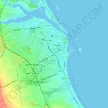
Name: Blyth topographic map, elevation, terrain.
Location: Blyth, Northumberland, North East, England, United Kingdom (55.09630 -1.58667 55.13922 -1.48934)
Average elevation: 8 m
Minimum elevation: -2 m
Maximum elevation: 47 m
Make a donation
Other topographic maps
Click on a map to view its topography, its elevation and its terrain.
Sharp Law
United Kingdom > England > Northumberland > Crookham > Crookham Eastfield
Average elevation: 56 m
Make a donation
Make a donation
Make a donation
Make a donation
Make a donation
Make a donation
Catcleugh Reservoir
United Kingdom > England > Northumberland
Catcleugh Reservoir is a reservoir in Northumberland, England, adjacent to the A68 road just north of Byrness and to the southeast of the border with Scotland. It has a surface area of 98.654 ha and a mean depth of 9.8 m, a catchment area of 4007.5 ha, and is situated at 247 m altitude.
Average elevation: 316 m
Make a donation
Make a donation
Amble
United Kingdom > England > Northumberland
Samuel Lewis reported a township population of 247 in 1831. By the seventh edition of his Topographical Dictionary of England, which was published in 1848, this figure had risen to 724. The population was reported as being 1,040 in 1851. The 1871 census recorded a population of 1,233, spread among 233 houses.
Average elevation: 15 m
Make a donation
Make a donation
Make a donation
Make a donation
Make a donation
Make a donation
Make a donation
Make a donation
Make a donation
Make a donation
Make a donation
Make a donation
Make a donation
Make a donation
Make a donation
Make a donation
Make a donation