
Thank you for supporting this site ❤️
Make a donation
Make a donation
Mpembeni topographic map
Click on the map to display elevation.
Thank you for supporting this site ❤️
Make a donation
Make a donation
About this map
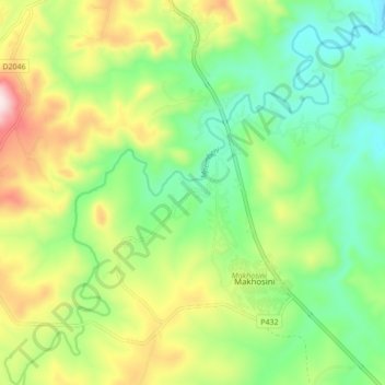
Name: Mpembeni topographic map, elevation, terrain.
Average elevation: 657 m
Minimum elevation: 487 m
Maximum elevation: 954 m
Thank you for supporting this site ❤️
Make a donation
Make a donation
Other topographic maps
Click on a map to view its topography, its elevation and its terrain.
Makhosini
South Africa > KwaZulu-Natal > Zululand District Municipality > Ulundi Local Municipality
Average elevation: 650 m