
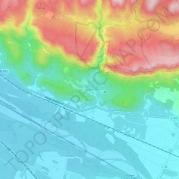
Riofret topographic map
Interactive map
Click on the map to display elevation.
About this map
Name: Riofret topographic map, elevation, terrain.
Average elevation: 188 m
Minimum elevation: 97 m
Maximum elevation: 385 m
Other topographic maps
Click on a map to view its topography, its elevation and its terrain.
La Tuilère
France > Provence-Alpes-Côte d'Azur > Vaucluse > Cheval-Blanc
La Tuilère, Cheval-Blanc, Apt, Vaucluse, Provence-Alpes-Côte d'Azur, France métropolitaine, 84460, France
Average elevation: 190 m
La Canebière
France > Provence-Alpes-Côte d'Azur > Vaucluse > Cheval-Blanc > La Canebière
La Canebière, Cheval-Blanc, Apt, Vaucluse, Provence-Alpes-Côte d'Azur, France métropolitaine, 84460, France
Average elevation: 102 m
L'Aumône
France > Provence-Alpes-Côte d'Azur > Vaucluse > Cheval-Blanc
L'Aumône, Cheval-Blanc, Apt, Vaucluse, Provence-Alpes-Côte d'Azur, France métropolitaine, 84460, France
Average elevation: 179 m