
Manomet Heights topographic map
Interactive map
Click on the map to display elevation.
About this map
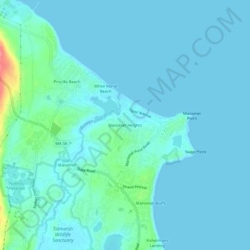
Name: Manomet Heights topographic map, elevation, terrain.
Average elevation: 10 m
Minimum elevation: 0 m
Maximum elevation: 78 m
Other topographic maps
Click on a map to view its topography, its elevation and its terrain.
Round Pond
United States > Massachusetts > Plymouth County > Plymouth
Round Pond, Plymouth, Plymouth County, Massachusetts, United States
Average elevation: 35 m
Beach Park
United States > Massachusetts > Plymouth County > Plymouth > Beach Park
Beach Park, Plymouth, Plymouth County, Massachusetts, 02360, United States
Average elevation: 18 m