
Riobamba topographic map
Interactive map
Click on the map to display elevation.
About this map
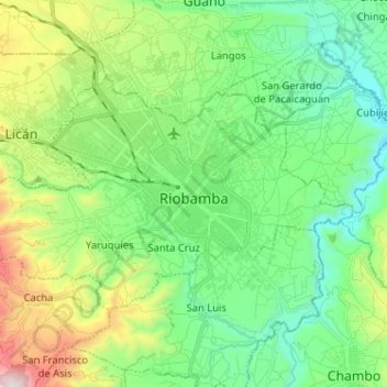
Name: Riobamba topographic map, elevation, terrain.
Location: Riobamba, Chimborazo, Ecuador (-1.71056 -78.72359 -1.63288 -78.59549)
Average elevation: 2,815 m
Minimum elevation: 2,465 m
Maximum elevation: 3,682 m
Riobamba liegt in der zentralen Sierra in 2750 Metern Höhe in einem Becken der Anden im Tal des Flusses Río Chambo. Es ist umgeben von den schneebedeckten und zum Teil aktiven Vulkanen Chimborazo (6310 m), El Altar (5319 m), Carihuairazo (5020 m), Tungurahua (5023 m), Cubillín (4711 m) und Sangay (5230 m). Bis auf den Sangay sind alle von der Stadt aus zu sehen. Wegen seiner Lage wird Riobamba daher von Einheimischen auch als „Sultanin der Anden“ bezeichnet.