
Biosphärenpark Salzburger Lungau und Kärntner Nockberge topographic map
Interactive map
Click on the map to display elevation.
About this map
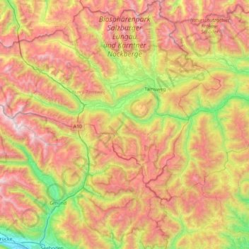
Name: Biosphärenpark Salzburger Lungau und Kärntner Nockberge topographic map, elevation, terrain.
Average elevation: 1,648 m
Minimum elevation: 539 m
Maximum elevation: 2,982 m
Other topographic maps
Click on a map to view its topography, its elevation and its terrain.
Stranach
Autriche > Salzbourg > Bezirk Tamsweg > Sankt Michael im Lungau > St. Michael im Lungau
Stranach, St. Michael im Lungau, Sankt Michael im Lungau, Bezirk Tamsweg, Salzbourg, 5582, Autriche
Average elevation: 1,283 m