
Make a donation
Dêqên County topographic map
Click on the map to display elevation.
Make a donation
Dêqên County
Being located at an altitude of 3,300 metres (10,800 ft), Dêqên lies in the transition between a subtropical highland climate (Köppen Cwb) and humid continental climate (Köppen Dwb), which is remarkable for its latitude. Although mean maximum temperatures, as in Lhasa and Shigatse, stay above freezing year-round, minima are below freezing from November to March, and temperatures average −1.4 °C (29.5 °F) in January, 13.6 °C (56.5 °F) in July, while the annual mean is 6.32 °C (43.4 °F). The town is nonetheless a little warmer during the winter than Shangri-La County to the east despite being slightly higher in elevation, due to its more southerly aspect. Rainfall is concentrated between June and September, accounting for nearly 60% of the annual total of 640 mm (25.2 in); snowfall is rare but still causes major transport problems in the winter. With monthly percent possible sunshine ranging from 29% in July to 62% in December, the county seat receives 1,989 hours of bright sunshine annually, with autumn and winter sunnier than spring and summer.
Make a donation
About this map
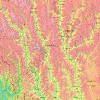
Name: Dêqên County topographic map, elevation, terrain.
Location: Dêqên County, Diqing, Yunnan, China (27.55823 98.59286 29.22572 99.52114)
Average elevation: 3,590 m
Minimum elevation: 1,022 m
Maximum elevation: 6,429 m
Make a donation
Other topographic maps
Click on a map to view its topography, its elevation and its terrain.
Jade Dragon Snow Mountain
China > Yunnan > Lijiang City
The view of the massif from the gardens at the Black Dragon Pool (Heilong Tan) in Lijiang is noted as one of China's finest views. The mountain is part of Yulong Snow Mountain National Scenic Area and National Geological Park, an AAAAA-classified scenic area. The Park operates a tourist cable car that climbs…
Average elevation: 4,829 m