
Zaozhuang topographic map
Interactive map
Click on the map to display elevation.
About this map
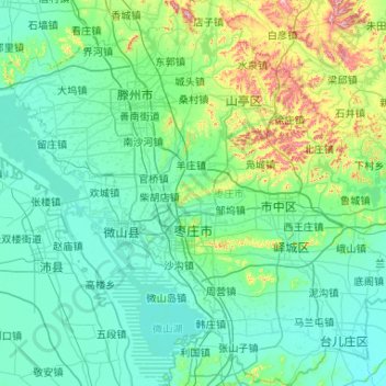
Name: Zaozhuang topographic map, elevation, terrain.
Location: Zaozhuang, Shandong, China (34.46237 116.80497 35.32174 117.83048)
Average elevation: 97 m
Minimum elevation: 22 m
Maximum elevation: 636 m
Other topographic maps
Click on a map to view its topography, its elevation and its terrain.
Linyi County
China > Shandong > Linyi County
Linyi County, Dezhou City, Shandong, 251500, China
Average elevation: 19 m