
Thank you for supporting this site ❤️
Make a donation
Make a donation
Barahona topographic map
Click on the map to display elevation.
Thank you for supporting this site ❤️
Make a donation
Make a donation
About this map
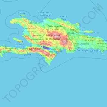
Name: Barahona topographic map, elevation, terrain.
Location: Barahona, Dominican Republic (15.57148 -73.80953 20.77148 -68.60953)
Average elevation: 88 m
Minimum elevation: -44 m
Maximum elevation: 2,981 m
Thank you for supporting this site ❤️
Make a donation
Make a donation
Other topographic maps
Click on a map to view its topography, its elevation and its terrain.
Santiago de los Caballeros
Santiago de los Caballeros (Spanish pronunciation: [sanˈtjaɣo ðe los kaβaˈʝeɾos]; English: Saint James of the Knights), often shortened to Santiago, is the second-largest city in the Dominican Republic and the fourth-largest city in the Caribbean by population. It is the capital of Santiago Province and…
Average elevation: 341 m