
Thank you for supporting this site ❤️
Make a donation
Make a donation
Post topographic map
Click on the map to display elevation.
Thank you for supporting this site ❤️
Make a donation
Make a donation
About this map
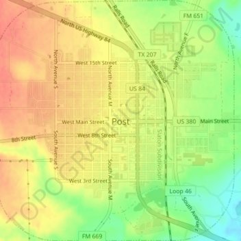
Name: Post topographic map, elevation, terrain.
Location: Post, Garza County, Texas, 79356, United States (33.17645 -101.39875 33.20565 -101.36421)
Average elevation: 793 m
Minimum elevation: 763 m
Maximum elevation: 812 m
Thank you for supporting this site ❤️
Make a donation
Make a donation
Other topographic maps
Click on a map to view its topography, its elevation and its terrain.