
Thank you for supporting this site ❤️
Make a donation
Make a donation
Chakrata topographic map
Click on the map to display elevation.
Thank you for supporting this site ❤️
Make a donation
Make a donation
Chakrata
It lies between the Tons and Yamuna rivers, at an elevation of 2118 m, 98 km from the state capital, Dehradun. Chakrata was originally a cantonment of the British Indian Army. To the west lies Shillai, Himachal Pradesh, and to the east are Mussoorie (73 km) and Tehri Garhwal.
Thank you for supporting this site ❤️
Make a donation
Make a donation
About this map
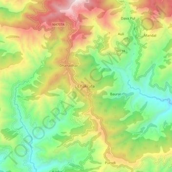
Name: Chakrata topographic map, elevation, terrain.
Location: Chakrata, Dehradun, Uttarakhand, 248123, India (30.66132 77.83034 30.74132 77.91034)
Average elevation: 1,851 m
Minimum elevation: 1,220 m
Maximum elevation: 2,780 m
Thank you for supporting this site ❤️
Make a donation
Make a donation