
Make a donation
Charlotte Harbor topographic map
Click on the map to display elevation.
Make a donation
About this map
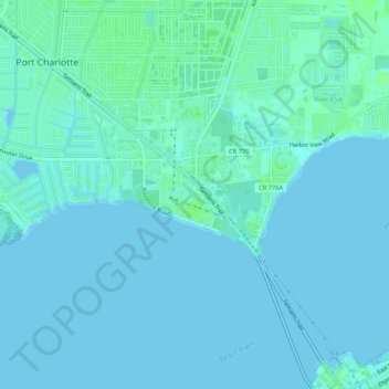
Name: Charlotte Harbor topographic map, elevation, terrain.
Location: Charlotte Harbor, Charlotte County, Florida, United States (26.94547 -82.08462 26.97466 -82.03179)
Average elevation: 2 m
Minimum elevation: -2 m
Maximum elevation: 9 m
Make a donation
Other topographic maps
Click on a map to view its topography, its elevation and its terrain.
Punta Gorda
United States > Florida > Charlotte County
Punta Gorda features a predominantly flat topography characterized by its low elevation, averaging around 7 to 10 feet above sea level. The terrain is primarily made up of coastal plains and wetlands, interspersed with small hills such as those found in South Punta Gorda Heights, which can reach elevations of…
Average elevation: 3 m
Punta Gorda Isles
United States > Florida > Charlotte County > Punta Gorda > Punta Gorda Isles
Average elevation: 2 m
Make a donation
Make a donation
Make a donation
South Punta Gorda Heights
United States > Florida > Charlotte County > Punta Gorda
Average elevation: 8 m
Make a donation
Make a donation
Make a donation
Placida
United States > Florida > Charlotte County
Placida is located at 26°49′55″N 82°15′54″W / 26.83194°N 82.265°W / 26.83194; -82.265Coordinates: 26°49′55″N 82°15′54″W / 26.83194°N 82.265°W / 26.83194; -82.265 (26.83194, -82.265). Placida has an elevation of 3 feet.
Average elevation: 1 m
Make a donation