
Make a donation
St. John River topographic map
Click on the map to display elevation.
Make a donation
About this map
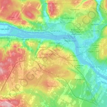
Name: St. John River topographic map, elevation, terrain.
Average elevation: 76 m
Minimum elevation: -2 m
Maximum elevation: 196 m
Make a donation
Other topographic maps
Click on a map to view its topography, its elevation and its terrain.
Fredericton
Canada > New Brunswick > Kingsclear Parish > Fredericton
At an altitude of about 17 m (56 ft) above sea level, Fredericton is nestled in the Pennsylvanian Basin. It differs markedly from the geologically older parts of the province. There are prominently two distinct areas in the region that are divided around the area of Wilsey Road, in the east end of the city. In…
Average elevation: 72 m
Make a donation
Make a donation
City of Fredericton
At an altitude of about 17 m (56 ft) above sea level, Fredericton is nestled in the Pennsylvanian Basin. It differs markedly from the geologically older parts of the province. There are prominently two distinct areas in the region that are divided around the area of Wilsey Road, in the east end of the city. In…
Average elevation: 71 m
Make a donation
Make a donation
Make a donation
Make a donation
Make a donation
Make a donation
Make a donation
Make a donation
Make a donation
Make a donation
Make a donation
Make a donation
Make a donation
Make a donation
Make a donation
Make a donation
City of Saint John
Canada > New Brunswick > Saint John County
The topography surrounding Saint John is hilly; a result of the influence of two coastal mountain ranges which run along the Bay of Fundy – the St. Croix Highlands and the Caledonia Highlands. The soil throughout the region is extremely rocky with frequent granite outcrops. The coastal plain hosts numerous…
Average elevation: 36 m
Hayesville
Canada > New Brunswick > Capital Region Rural District > Stanley Parish
Average elevation: 306 m
Make a donation
Make a donation
Fredericton
Canada > New Brunswick > City of Fredericton
At an altitude of about 17 m (56 ft) above sea level, Fredericton is nestled in the Pennsylvanian Basin. It differs markedly from the geologically older parts of the province. There are prominently two distinct areas in the region that are divided around the area of Wilsey Road, in the east end of the city. In…
Average elevation: 69 m
Make a donation
Make a donation
Make a donation
Make a donation
Make a donation