
1471 topographic map
Interactive map
Click on the map to display elevation.
About this map
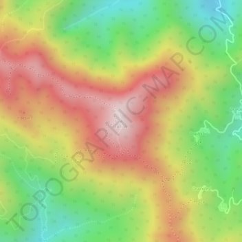
Name: 1471 topographic map, elevation, terrain.
Location: 1471, Provinz Chiang Mai, Thailand (19.28465 98.88723 19.28475 98.88733)
Average elevation: 1,194 m
Minimum elevation: 913 m
Maximum elevation: 1,451 m
Other topographic maps
Click on a map to view its topography, its elevation and its terrain.
ท่าศาลา
ท่าศาลา, ต้นเปา, อำเภอสารภี, Provinz Chiang Mai, 50140, Thailand
Average elevation: 304 m
อ่างข่าง
Thailand > Provinz Chiang Mai > อ่างข่าง
อ่างข่าง, Provinz Chiang Mai, Thailand
Average elevation: 1,533 m