
Seweweekspoortpiek topographic map
Interactive map
Click on the map to display elevation.
About this map
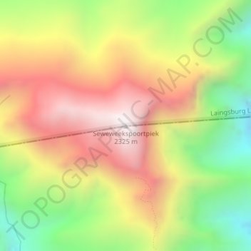
Name: Seweweekspoortpiek topographic map, elevation, terrain.
Average elevation: 1,769 m
Minimum elevation: 1,196 m
Maximum elevation: 2,311 m
Other topographic maps
Click on a map to view its topography, its elevation and its terrain.
Buffels
RSA > Western Cape > Laingsburg Local Municipality
Buffels, Laingsburg Local Municipality, Central Karoo District Municipality, Western Cape, RSA
Average elevation: 838 m
Anysberg Nature Reserve
RSA > Western Cape > Laingsburg Local Municipality
Anysberg Nature Reserve, Landsekloof (4x4), Laingsburg Ward 2, Laingsburg Local Municipality, Central Karoo District Municipality, Western Cape, RSA
Average elevation: 802 m