Geolocate

Shire Of Collie topographic map

Interactive map

Click on the map to display elevation.

About this map

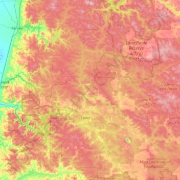
Name: Shire Of Collie topographic map, elevation, terrain.

Location: Shire Of Collie, Western Australia, Australia (-33.55249 115.91858 -32.99457 116.41241)

Average elevation: 241 m

Minimum elevation: 13 m

Maximum elevation: 437 m

Other topographic maps

Click on a map to view its topography, its elevation and its terrain.

Albany

Australia > Western Australia

Average elevation: 30 m

Elephant Rock

Australia > Western Australia > Kununurra

Average elevation: 51 m

Perth

Australia > Western Australia > City of Perth

Perth, the capital of Western Australia, is situated on the Swan Coastal Plain, a flat expanse of sandy soil nestled between the Indian Ocean to the west and the Darling Scarp to the east. The Darling Scarp, also known as the Darling Range, is a low escarpment that extends north–south, marking a distinct…

Average elevation: 26 m

Wellington Dam

Australia > Western Australia

Average elevation: 191 m

Broome

Australia > Western Australia

Average elevation: 8 m

Macleay Island

Australia > Western Australia

Average elevation: 4 m

Mammoth Cave

Australia > Western Australia

Average elevation: 72 m

Northam

Australia > Western Australia > Northam

Average elevation: 182 m

Greenstone Hill

Australia > Western Australia > Wiluna

Average elevation: 479 m