
Thank you for supporting this site ❤️
Make a donation
Make a donation
Huancaray topographic map
Click on the map to display elevation.
Thank you for supporting this site ❤️
Make a donation
Make a donation
About this map
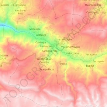
Name: Huancaray topographic map, elevation, terrain.
Location: Huancaray, Andahuaylas, Apurímac, Perú (-13.84416 -73.60035 -13.69302 -73.49846)
Average elevation: 3,635 m
Minimum elevation: 2,431 m
Maximum elevation: 4,321 m
Thank you for supporting this site ❤️
Make a donation
Make a donation
Other topographic maps
Click on a map to view its topography, its elevation and its terrain.