
Thank you for supporting this site ❤️
Make a donation
Make a donation
Willingen topographic map
Click on the map to display elevation.
Thank you for supporting this site ❤️
Make a donation
Make a donation
About this map
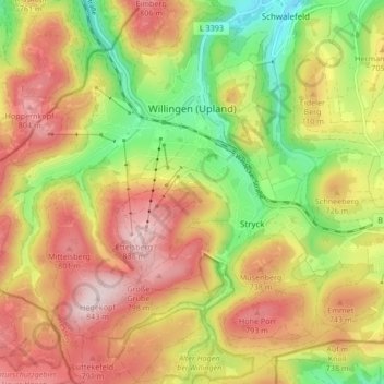
Name: Willingen topographic map, elevation, terrain.
Average elevation: 680 m
Minimum elevation: 503 m
Maximum elevation: 844 m
Thank you for supporting this site ❤️
Make a donation
Make a donation
Other topographic maps
Click on a map to view its topography, its elevation and its terrain.
Thank you for supporting this site ❤️
Make a donation
Make a donation
Rothaargebirge
Duitsland > Hessen > Landkreis Waldeck-Frankenberg > Willingen
Average elevation: 727 m