
Yonah Mountain topographic map
Interactive map
Click on the map to display elevation.
About this map
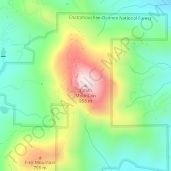
Name: Yonah Mountain topographic map, elevation, terrain.
Location: Yonah Mountain, White County, Georgia, United States (34.63756 -83.71340 34.63766 -83.71330)
Average elevation: 619 m
Minimum elevation: 428 m
Maximum elevation: 953 m
Other topographic maps
Click on a map to view its topography, its elevation and its terrain.
Helen
United States > Georgia > White County
Helen, White County, Georgia, 30545, United States
Average elevation: 488 m
Unicoi Lake
United States > Georgia > White County
Unicoi Lake, White County, Georgia, United States
Average elevation: 562 m
Nacoochee
United States > Georgia > White County
Nacoochee, White County, Georgia, 30545, United States
Average elevation: 449 m
Raven Cliff Falls
United States > Georgia > White County
Raven Cliff Falls, White County, Georgia, United States
Average elevation: 922 m
Cleveland
United States > Georgia > White County
Cleveland, White County, Georgia, 30528, United States
Average elevation: 479 m
Mossy Creek
United States > Georgia > White County
Mossy Creek, White County, Georgia, United States
Average elevation: 416 m
Sautee
United States > Georgia > White County
Sautee, White County, Georgia, 30571, United States
Average elevation: 441 m
Smithgall Woods State Park
United States > Georgia > White County
Smithgall Woods State Park, White County, Georgia, United States
Average elevation: 612 m