
Make a donation
Balderschwang topographic map
Click on the map to display elevation.
Make a donation
About this map
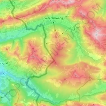
Name: Balderschwang topographic map, elevation, terrain.
Average elevation: 1,244 m
Minimum elevation: 830 m
Maximum elevation: 1,777 m
Make a donation
Other topographic maps
Click on a map to view its topography, its elevation and its terrain.
Fischen im Allgäu
Duitsland > Beieren > Landkreis Oberallgäu > Fischen im Allgäu
Average elevation: 817 m
Hof
Duitsland > Beieren > Landkreis Oberallgäu > Fischen im Allgäu > Langenwang
Average elevation: 849 m
Make a donation
Obergschwend
Duitsland > Beieren > Landkreis Oberallgäu > Bad Hindelang > Unterjoch
Average elevation: 1,236 m
Make a donation
Winkel
Duitsland > Beieren > Landkreis Oberallgäu > Oberstdorf > Tiefenbach
Average elevation: 1,017 m
Oberschwarzenberg
Duitsland > Beieren > Landkreis Oberallgäu > Oy-Mittelberg > Unterschwarzenberg
Average elevation: 890 m
Make a donation
Oberstdorf
Duitsland > Beieren > Landkreis Oberallgäu > Oberstdorf > Oberstdorf
Average elevation: 1,098 m