
Kedungpane topographic map
Interactive map
Click on the map to display elevation.
About this map
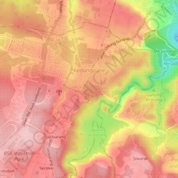
Name: Kedungpane topographic map, elevation, terrain.
Location: Kedungpane, Mijen, Semarang, Java central, Indonésie (-7.05155 110.33034 -7.01463 110.36462)
Average elevation: 179 m
Minimum elevation: 35 m
Maximum elevation: 242 m
Other topographic maps
Click on a map to view its topography, its elevation and its terrain.
Kauman
Indonésie > Java central > Semarang
Kauman, Semarang Tengah, Semarang, Java central, Indonésie
Average elevation: 7 m
Bulusan
Indonésie > Java central > Semarang
Bulusan, Tembalang, Semarang, Java central, Jawa, 50277, Indonésie
Average elevation: 140 m