
Thank you for supporting this site ❤️
Make a donation
Make a donation
Infanta topographic map
Click on the map to display elevation.
Thank you for supporting this site ❤️
Make a donation
Make a donation
About this map
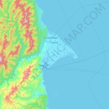
Name: Infanta topographic map, elevation, terrain.
Location: Infanta, Quezon, Calabarzon, 4336, Philippines (14.53426 121.43761 14.87463 121.83551)
Average elevation: 162 m
Minimum elevation: -1 m
Maximum elevation: 1,201 m
Thank you for supporting this site ❤️
Make a donation
Make a donation