
Thank you for supporting this site ❤️
Make a donation
Make a donation
Condoroma topographic map
Click on the map to display elevation.
Thank you for supporting this site ❤️
Make a donation
Make a donation
About this map
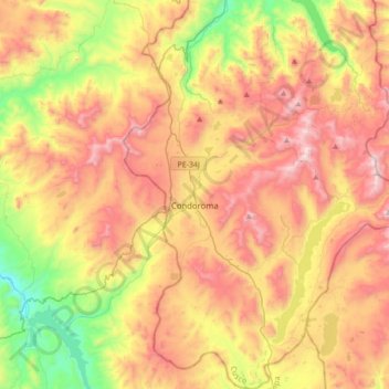
Name: Condoroma topographic map, elevation, terrain.
Location: Condoroma, Espinar, Cusco, Perú (-15.45829 -71.20208 -15.12397 -70.95003)
Average elevation: 4,668 m
Minimum elevation: 4,102 m
Maximum elevation: 5,245 m
Thank you for supporting this site ❤️
Make a donation
Make a donation
Other topographic maps
Click on a map to view its topography, its elevation and its terrain.